Subject:
John, I don't think we're
in Kansas anymore...Oklahoma!
Date: Tue,
09 Sep 1997 22:22:30 -0700
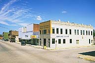
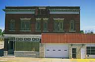
 Galena, Kansas
20:35 Bernice State Park; Bernice, Oklahoma :: 09 SEP
97
We're pulled up beside a reservoir. The air has cooled from
its mid-day sombre mugginess and the night sky is crisp and clear with
the half-moon's silver reflecting off the water below. It's perfect except
for the fickle breeze that wafts campfire smoke in every direction so
that no place around the fire is safe. And I could do with a few less
of the pesky bugs attracted to the computer screen's light. But near perfect
is quite acceptable, and the night is so much friendlier with the calls
of crickets, cicadas and other night-time insects not so taken with the
dim light issuing from a laptop.
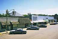
After a marathon crossing of Missouri yesterday, nearly half
the state in a single go, we managed no more than 40 miles today. A late
start, a snail's pace and a lingering stop in Baxter, Kansas conspired
delightfully to keep the distance short, but the memories lengthy. On
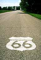
the other hand, we traversed every single foot of Route 66 we could find
in Kansas in a single day. About 13 miles or so. And in Baxter I realized
I'd been going about the Route 66 back-story all wrong. I'll talk about
the marvellous experience of Baxter Spring's museum in another post. For
the moment, suffice it to say it is a beautifully conceived and executed
museum run on a small-town's budget offset by the requisite small-town
heart, dedication and TLC. Today it proved to be a great resource and
a friendly place to stop and talk history.
Route 66 was cobbled together from disparate sections of existing roadways.
Each of these sections have their own stories to tell. That is, in 1926
the highway came into existence as a transcontinental route, but this
is genesis by decree rather than an original act of creation. Much, if
not most, of the original 1926 alignment of Route 66 already had a long
history by the time a couple signatures on a piece of paper declared it
America's first major interstate. And this history predates America itself.
It would be an Oddyssean task to tell the entire Mother Road's
history in this way, to name every stretch of highway and tell its story.
It would make for a beautiful songline, (See Dreamtime)
but I have neither the heritage nor the expertise to write that song,
and certainly not the time. Instead, I'll hum a few bars about a short
section in Kansas connecting Riverton and Baxter. You'll get a little
taste of it that way.
Animals of all sorts make paths and trails simply by wearing
a particular area stretching between two places frequented by the animals.
Ants do this all the time, as do herd animals between watering holes and
feeding grounds. The worn in path is easier to follow and navigate.
Human beings add a second dimension to this, technology. We
don't merely wear a path in; with tools we can clear and pave one. I don't
know how much technology was required to establish the Black Dog Trail.
I'm not even certain which tribe must be credited with its creation. The
Quapaw eventually came to settle this region, but only at the request
of the US government which insisted the tribe leave Arkansas early in
the 19th century. Apparently, they used the Black Dog Trail for a number
of years, right up until someone else found a use for it. They've been
sharing the trail ever since.
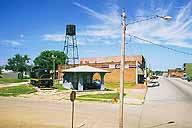
The folks at Baxter Spring's Museum were kind enough to photocopy
a few newspaper and magazine articles referring to Military Road, Baxter's
main avenue. It also served as Route 66 for as long as The Mother Road
existed. Going through Baxter, it's now marked as State Road 69A but continues
to carry the name Military Road on street signs at every block.
This is one road in a large network of roads. During the westward
expansion of the 1800's the US Military built and maintained numerous
forts supplied by an intricate web of military trails. If you remember
your US history, you'll recall that America's often hostile neighbours
and co-inhabitors of what is now the continental United States included
the Spanish in the southwest (later, independent Mexico) and in the south,
the French and Spanish in the Midwest. The English were to the north and
cohabitating the Oregon Territory. And of course, the Indian Nations buzzed
all about the hive. There were plenty of good reasons to build forts and
plenty more good reasons to maintain roads for supply and troop movement.
All the Baxter Museum's photocopied articles refer to Military
Road as if it were blazed by the Army but, at least for the section passing
through the vicinity of Baxter, I am assured by the folks in Baxter Springs
that Black Dog Trail preceded Military Road, just as Military Road preceded
Route 66, which preceded State Road 69A. Overtime, the alignments follow
new paths through the countryside. The needs of a traveler on foot differ
from the mounted, from wagoners and from cars and trucks. We build towns
on our highways, as Baxter Springs was built on Military Road, and as
Kansas City grew on the intersection of the Oregon Trail, Santa Fe Trail
and the Leavenworth-Ft. Gibson Military Road. As road and town grow, the
needs of the traveler dictate a by pass. If towns along a road fail and
die, so might the road. As technologies and established infrastructures
change, so to do the modes of travel and, possibly, the routes. Baxter
Springs was established only three years before the railroad came through,
closely following the alignment of the Leavenworth-Ft. Gibson trail. Route
69 closely follows the alignment of the railroads. From Riverton to Baxter,
old Route 66 closely followed them all. But the local Mother Road was
the Black Dog Trail, which preceded them all.
I know all this history has been a jumbled mess, but you're
the unfortunate lot to hear me tell it as I learn it. As I fill in yesterday's
gaps today, I'm uncovering tomorrow's.
~~~ Responses Sought ~~~
Men stood by their fences and looked at the ruined
corn, drying fast now, only a little green showing through the film of
dust. The men were silent and they did not move often. And the women came
out of the houses to stand by their men-to feel whether this time the
men would break. The women studied the men's faces secretly, for the corn
could go, as long as something else remained.


 symbol of Yin & Yang, balance; Peace Sign; Cupid Heart for Love; Ankh for life: printed on buttons, stickers, t-shirts, hoodies, posters and more")